No products in the cart.
Feasibility Studies | Geospatial Engineers Propel Your Fiber Network Design
Home Feasibility Studies | Geospatial Engineers Propel Your Fiber Network Design
- Home
- Resource Hub
- Millennium Blog
- Feasibility Studies | Geospatial Engineers Propel Your Fiber Network Design
Feasibility Studies | Geospatial Engineers Propel Your Fiber Network Design
At the core of building a resilient, future-proof network is the execution of a comprehensive feasibility study. With fierce competition for BEAD funding and other broadband grants, securing these critical opportunities requires more than just a persuasive narrative about your network’s community benefits. It demands a demonstration of both technical and financial feasibility. A well-conducted feasibility study is key to validating your project’s viability and strengthening your business case.
Top 5 Reasons to Perform a Feasibility Study
Every broadband project has unique engineering requirements based on site geography and existing infrastructure. An in-depth feasibility study helps pinpoint where, when, and how to build your network, avoiding costly mistakes and ensuring a clear understanding of your ROI before breaking ground. The Broadband, Equity, Access, and Deployment (BEAD) Program requires a high-level design and corresponding budget as part of your broadband funding application. A feasibility study will provide you with the information you need.
1. Estimate Project Costs
2. Determine Project Take Rate
3. Calculate Anticipated ROI
4. High-level Design for BEAD Application
5. Accelerates Fiber Construction Projects
Previous slide
Next slide
Broadband Feasibility Studies Set the Pace for Success
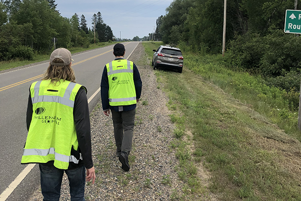
Securing geospatial engineering consultants for a feasibility study can strengthen your broadband grant application and find fiber construction efficiencies that speed up time to market. When Imagine Networks partnered with Millennium Engineering on a feasibility study, leveraging GIS tools for reliable data, they confidently greenlit their FTTH expansion. Explore their experience with GIS planning and design in this case study.
How Geospatial Engineering Accelerates Fiber Construction
Optimizes Route Planning
Facilitates Precise Project Management and Tracking

Streamlines Permitting
How to Build Your Feasibility Study for BEAD Funding
Partnering with Millennium Engineering for outsourced geospatial engineering services can significantly enhance your ability to manage a surge in construction projects, resolve data discrepancies to determine take rates, or navigate complex projects that may be beyond the scope of your in-house team’s capabilities. Our geospatial engineering expertise enables you to quickly advance project milestones, a crucial advantage when facing tight BEAD program deadlines.
- Determine Community Needs
- Conduct Infrastructure Audit
- Create Fiber Network Design
- Make Financial Business Case
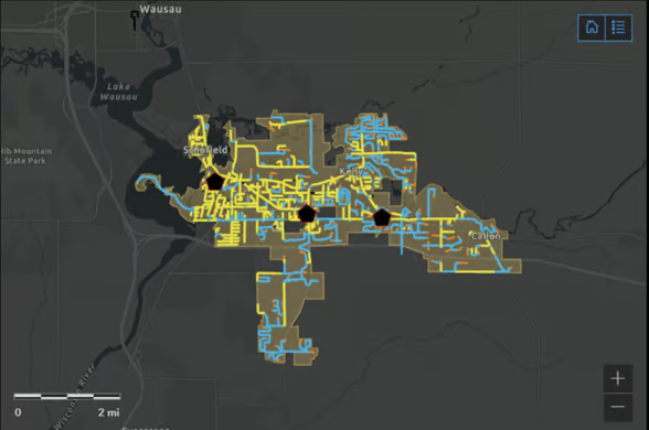
Use the FCC’s National Broadband Map to identify service gaps where you may want to expand your network. This map shows broadband availability down to location-specific data regarding internet coverage, speed of service, and which company is providing internet service. Recent broadband challenges led to the FCC vastly improving the map’s accuracy.
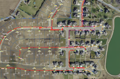
Geospatial engineering offers enhanced data visualization to find the most profitable routes for your fiber construction. Existing infrastructure and the geography of your potential site can affect your build and impact whether you need to build aerially, underground, or a combination of the two. Conducting an infrastructure audit will also help you map out the area regarding cables, poles, and equipment needed for your project to eliminate costly surprises.
Geospatial engineers have the technical know-how to combine data from multiple sources — GIS maps, company data, and more — to provide a complete high- and low-level design needed for BEAD applications.
Understanding your project economics — construction and operational costs and potential ROI – helps determine appropriate broadband funding requests. While your low-level design provides an overall project cost-benefit analysis, your high-level design dives deeper. It outlines your Bill of Materials (BOM) to provide precise budgeting needed for BEAD funding.
Benefits of Partnering with Expert Geospatial Engineers
Access Experts
Beyond feasibility studies, Millennium engineers can train your team on
everything from setting up a geospatial engineering department to
maintaining productivity.
Maximize your team's efficiency by:
1) Automating project hand-offs to streamline collaboration
2) Simplifying reports for easier analysis
3) Aligning team efforts for improved efficiency
Feasibility Studies + GIS Delivers Deployment Success
When connecting customers faster helps your community and business thrive, partnering with Millennium Engineering is worth the strategic investment. Ready to transform your community and business?
Contact Millennium Engineering today to start your feasibility study.
Future-Focused Network Owners from
Coast to Coast Look to Millennium For:
- Feasibility Studies & Network Design Plans
- Financing & Grants
- Project Resource Management
- Material Supply & Logistical Planning
- Equipment Leasing & Rentals

Millennium Engineering takes pride in being a recognized member of ESRI’s Silver Partner Network, highlighting our dedication to having a fully certified technical team accredited with the ESRI Release Ready Specialty. This alliance grants us access to ESRI’s top-tier ArcGIS software, renowned for its robust geolocational mapping and data intelligence capabilities that enhance insight gathering, data monitoring, and precise forecasting. Leveraging ESRI’s sophisticated tools and educational resources, Millennium Engineering consistently brings unmatched intelligence and operational efficiency to every network project.